Heather Calabro
Bloomfield Public Schools
TEACHER'S SNAPSHOT
Subjects:
Colonial History, Geography, Maps, Native/Indigenous Peoples
Course Topics/Big Ideas:
Role of Connecticut in U.S. History, The Impact of Geography on History
Town:
Simsbury
Grade:
Grade 8
Lesson Plan Notes
This activity will lead students on a virtual “hike” through the local geography and history of King Philip’s War. The Metacomet Trail may be a popular hiking trail today, but it has historical significance that many local residents are unaware of. The trail is named for the 17th-century Wampanoag leader Metacom, called “King Philip” by the English. The conflict known as King Philip’s War (1675-1676) was fought primarily over land and fair treatment under English laws, but also over whether the English would dominate the region. Most of the fighting took place in Rhode Island and Massachusetts, but there were also conflicts in Connecticut, including the destruction of the abandoned town of Simsbury in March 1676. In completing this activity, students will experience place-based learning and gain local historical and geographical knowledge through the exploration of topographical maps, analysis of written sources, and the creation of presentations with peer review.
ESSENTIAL QUESTION
SUPPORTING QUESTIONS
- How do geographers read topographical maps?
- What are the advantages and disadvantages of different landforms during conflict?
- How could local geography have affected Metacom and the war?
ACTIVITY
1. Ask students to complete this custom Placemat Consensus Kagan Structure activity to explore their prior knowledge of maps.
OR
Break the class into groups of 3-4 students, making sure each student has a paper and pen/pencil or someplace to write. Explain that after you read the question, students will have 7 seconds to think and then 30 seconds to write. Read the first question aloud: “What are maps used for?” Have students share their responses within the group and then share any similar answers with the whole class; record the responses, highlighting those that are similar across multiple groups. Repeat the process with the second question: “How are hills, mountains, and uneven land shown on maps?”
2. Ask students to complete this Topographical Map Analysis activity.
OR
Start by providing some background information about topographical maps. (Elevation is the height above sea level. Topographic maps show the shape and elevation of mountains, valleys, and plains and have many uses. Architects, builders, city planners, engineers, hikers, scientists, and skiers all use topographic maps regularly.) Show the “Topographical map example from the National Wildfire Coordinating Group” from the toolkit and explain that the lines on a topographic map are called contour lines. The contour lines show the elevation at each position. Contour lines that are spaced far apart show a gentle slope. Contour lines that are close together show a steep slope. Show students the “Topographical map of the James property and section of the Metacomet Trail in Simsbury.”
- Where on this map is the steepest?
- Where on this map is the flattest?
- How can you tell?
Next, compare this map with the “Tariffville Quadrangle 1984 – USGS Topographic Map.” Both are topographical maps, but the “James property” map is drawn at a 1:300 scale. That means one unit on the map is equal to 300 feet in real life. The Tariffville Quadrangle map is drawn at a 1:24,000 scale. That means one unit on the map is equal to 24,000 feet in real life.
Discuss why one scale might be useful for certain purposes, but another might be better for other purposes.
Conduct a closer examination of the Tariffville Quadrangle map.
- What do you see?
- How are the highest areas shown?
- How are the lowest areas shown?
- Are areas with water high or low elevations, typically?
3. Review landform Background Vocabulary from the toolkit with students. Ask students to work in pairs or small groups to describe different landforms and explain how they might be either beneficial or disadvantageous during times of conflict using this Landforms During Conflict activity.
OR
Have students work in pairs or small groups to define/describe the following land forms, locate a representative image of each, and identify how different landforms might be either beneficial or disadvantageous during times of conflict:
- Lake
- Mountain
- River
- Valley
- Peninsula
- Delta
- Hill
Students should present their work in small groups at the conclusion.
4. Ask students to complete this Historical Article Annotation. Students will compare and combine annotations at the conclusion of this activity.
OR
Have students read and annotate the article “Simsbury at the Time of King Philip’s War.” You may also want to share the photograph of Talcott Mountain provided in the toolkit, since this is the location of the cave mentioned in the article. Ask students to highlight the 6-8 most important pieces of information in the article and create a list of unfamiliar words or phrases, which they can then look up. In pairs, students should discuss what they think were the most important pieces of information in the article and come to a consensus.
OPPORTUNITIES FOR ASSESSMENT
- Using their historical article annotation of “Simsbury at the Time of King Philip’s War,” students will fill out the Written Explanation Framework (DOC/PDF) provided in the toolkit.
- Using the Infographic Instructions (DOC/PDF) provided in the toolkit, students will create their own infographic about King Philip’s War. Afterwards, students will present and provide peer feedback using the Peer Feedback Instructions (DOC/PDF) in the toolkit.
- Create a topographic map of your classroom: 1. Pass out materials—paper, pencil, rulers (optional). 2. If desired, distribute measurements in advance—classroom length and width, desk height, counter height, Promethean board height, etc. 3. Just like on the topographic map students explored earlier, the darkest lines on their map should represent the highest heights in the classroom. The lightest areas/lines should represent the lowest height (floor) in the classroom. Encourage students to attempt this exercise with as much detail as possible! 4. Share out in small groups. Or, conduct a gallery walk—each student leaves their map on their desk and everyone walks clockwise to view their classmates’ work.
RESOURCE TOOL KIT

Topographical map example from the National Wildfire Coordinating Group.
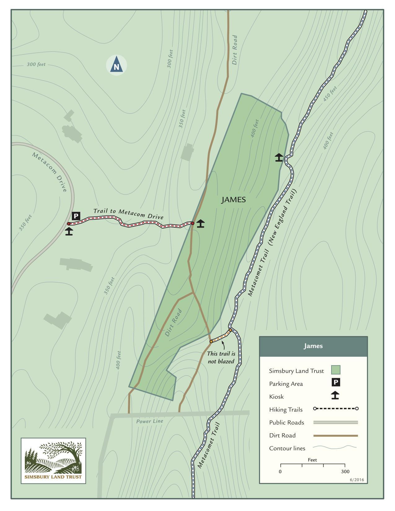
Topographical map of the James property and section of the Metacomet Trail in Simsbury, Simsbury Land Trust, 2016.
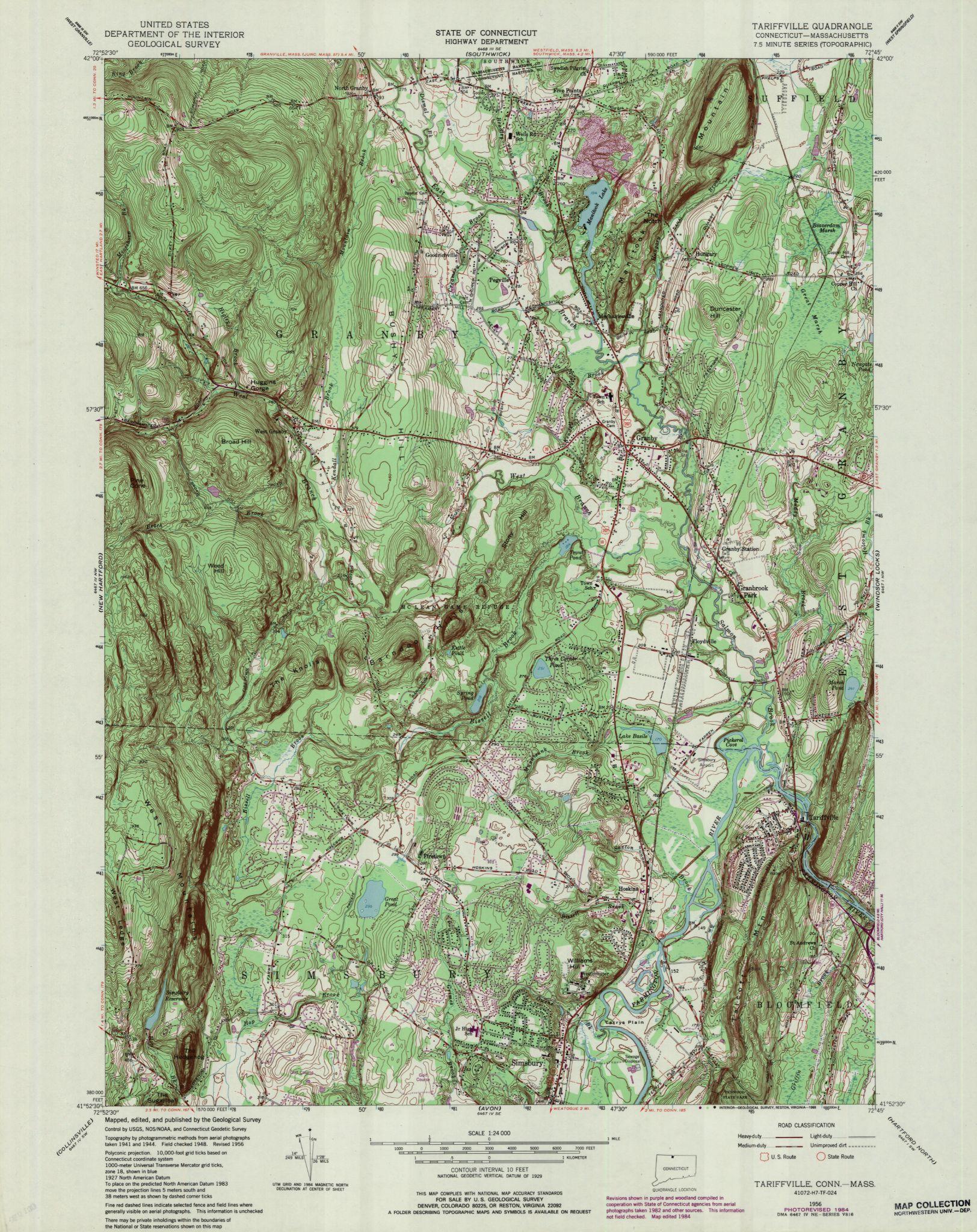
Tariffville Quadrangle 1984 – USGS Topographic Map 1:24,000. Connecticut USGS Topographic Map Collections, UConn Library Map and Geographic Information Center (MAGIC).

Background Vocabulary
“Simsbury at the Time of King Philip’s War” by Rebecca Furer, 2021.
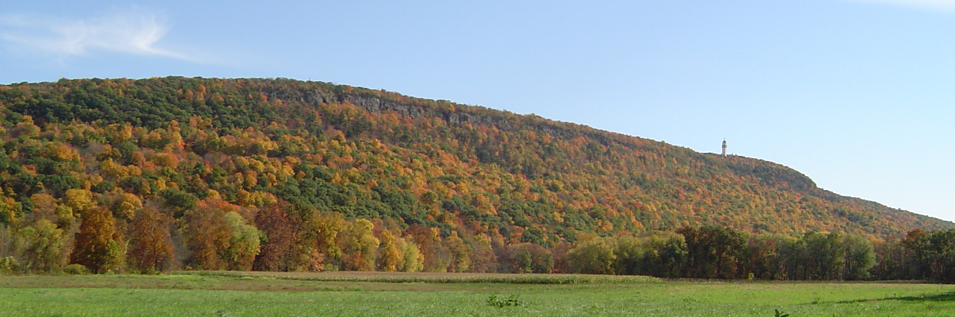
Talcott Mountain Fall, 2008. Courtesy Wikimedia Commons, licensed under the Creative Commons Attribution-Share Alike license.
ADDITIONAL RESOURCES
Places to GO
Talcott Mountain State Park, Simsbury
Simsbury Historical Society, Simsbury
Things To DO
Hike a portion of Metacomet Trail in Connecticut.
Watch King Philip’s War: The History & Legacy of America’s Forgotten Conflict, available as a downloadable video through many public libraries.
Websites to VISIT
History Matters: Metacom Relates Indian Complaints about the English Settlers, 1675
Our Beloved Kin: Remapping A New History of King Philip’s War
Articles to READ
ConnecticutHistory.org: “America’s Most Devastating Conflict: King Philip’s War” by Mike Messina for Your Public Media.
“Connecticut’s Contested 17th Century Landscape” by Brian Jones and Kevin McBride. Connecticut Explored, Summer 2019.