by Rebecca Furer for Teach It
TEACHER'S SNAPSHOT
Subjects:
Colonial History, Environment, Geography, Maps, Native/Indigenous Peoples, Transportation
Course Topics/Big Ideas:
Cultural Communities in Connecticut Present and Past, Innovation, Industry, and Economic Growth, Location, Place, and Movement, Migration and Settlement, Understanding Regions
Town:
Hartford, Middletown, New Haven, New London, Norfolk, Statewide, Storrs
Lesson Plan Notes
There are many ways to represent and record a place—pictures, stories, songs, poems, place names, or written descriptions—but maps are one of the most common. Different maps serve different purposes—marking boundaries, navigating, tracking information, assessing risk, illustrating historical events or landmarks, supporting the military, analyzing weather patterns, education, or countless other roles. There is a long history of mapmaking in Connecticut. This activity provides a variety of historic maps from a range of time periods for students to examine. While these maps may look different from the ones that students are familiar with, they are all rich in detail and historical context and can help build important skills in map reading and analysis.
ESSENTIAL QUESTION
SUPPORTING QUESTIONS
- What do maps show?
- What don’t they show?
- How can you represent a geographic place other than using a map?
- What is the relationship between where people live and what resources are important to them?
- What resources are shown on maps? What resources are not?
- Why do we live where we live?
- What makes Connecticut geographically similar to or different from other parts of the Northeast region or other parts of the country?
ACTIVITY
- Introduce the compelling question and have students develop some supporting questions to guide their inquiry. You may want to introduce some or all of the suggested supporting questions as well.
- Select one of the maps from the toolkit and model the analysis strategy together as a class. You may want to consult the Library of Congress’s Teacher’s Guide for Analyzing Maps.
WHAT DO YOU SEE? Does the map have a title? A date? The name of the mapmaker? Familiar map components, like a compass rose, scale, legend/key, or map grid? What places appear on the map? Does it show one town/small area, or a larger region? What geographic features are shown? What else can you notice?
WHAT DO YOU THINK? What do you think the purpose of this map was/why was it made? Who do you think the audience was/who was it made for? How is it different from or similar to other maps that you have seen? What does this map tell us about the time when it was made or the people who made it?
WHAT DO YOU WONDER? What questions do you have when you see this map? - Select another map to examine as a class and compare to the first or assign students in pairs or small groups to look at different maps and share their findings with the class. You may want to use the Library of Congress’s Primary Source Analysis Tool worksheet, provided in the toolkit.
- Revisit the supporting and compelling questions and make a plan for how students will further communicate their conclusions.
OPPORTUNITIES FOR ASSESSMENT
- Using a printout or digital image, students will annotate one of the historic maps in the toolkit based on their analysis and class discussion.
- Imagining they are cartographers/mapmakers, students will think about their own town and develop a list of all of the special places (public buildings, landmarks, public spaces, etc.) that they think should be included in a new map.
- Students will try their hand at making a map using rulers and graph paper. Making a map of the classroom is an easy project to start with; if your room has floor tiles, students can use those to mark out the dimensions on the graph paper.
- Starting with a blank map of their own town or of Connecticut, students will research and create their own map showing something of interest to them (e.g. favorite places to visit, where friends/relatives live, best ice cream shops/restaurants, hometowns of famous people from Connecticut, etc.). The maps should include a compass rose, grid, and legend. Students can then make a short map quiz to share with a classmate (e.g. “What is NW of _____?” “What ice cream shop is closest to _____?” or “What are the coordinates of ______?”)
RESOURCE TOOL KIT
Plan of the town of New Haven: with all the buildings in 1748. James Wadsworth, 18–. Connecticut Museum of Culture and History.
Plan of the east part of the colony of Connecticut in North America: shewing the situation of the lands in controversy between the inhabitants of that colony and the Moheagan Indians. 1760. Connecticut Museum of Culture and History.
Connecticut, from the best authorities delineated & engraved by A. Doolittle. New Haven, Conn.: A. Doolittle, [ca. 1800]. Connecticut Museum of Culture and History.
Map of the city of Middletown surveyed & delineated by H. L. Barnum, topographer. Engraved by J. T. Porter. 1825. University of Connecticut Libraries.
New Haven Harbor. United States Coast Survey, 186-. Library of Congress Geography and Map Division.
Bicycle road-map: New Haven, Connecticut, to New London, Connecticut. New York: Harper & Brothers, 1895. Library of Congress Geography and Map Division.
Sanborn Fire Insurance Map from Norfolk, Litchfield County, Connecticut. Sanborn Map Company, Oct, 1900. Image 1. Library of Congress Geography and Map Division.
Atlas of the City of Hartford, Plate 16. L. J. Richards & Co., 1909. Archives & Special Collections at the Thomas J. Dodd Research Center, University of Connecticut Libraries.
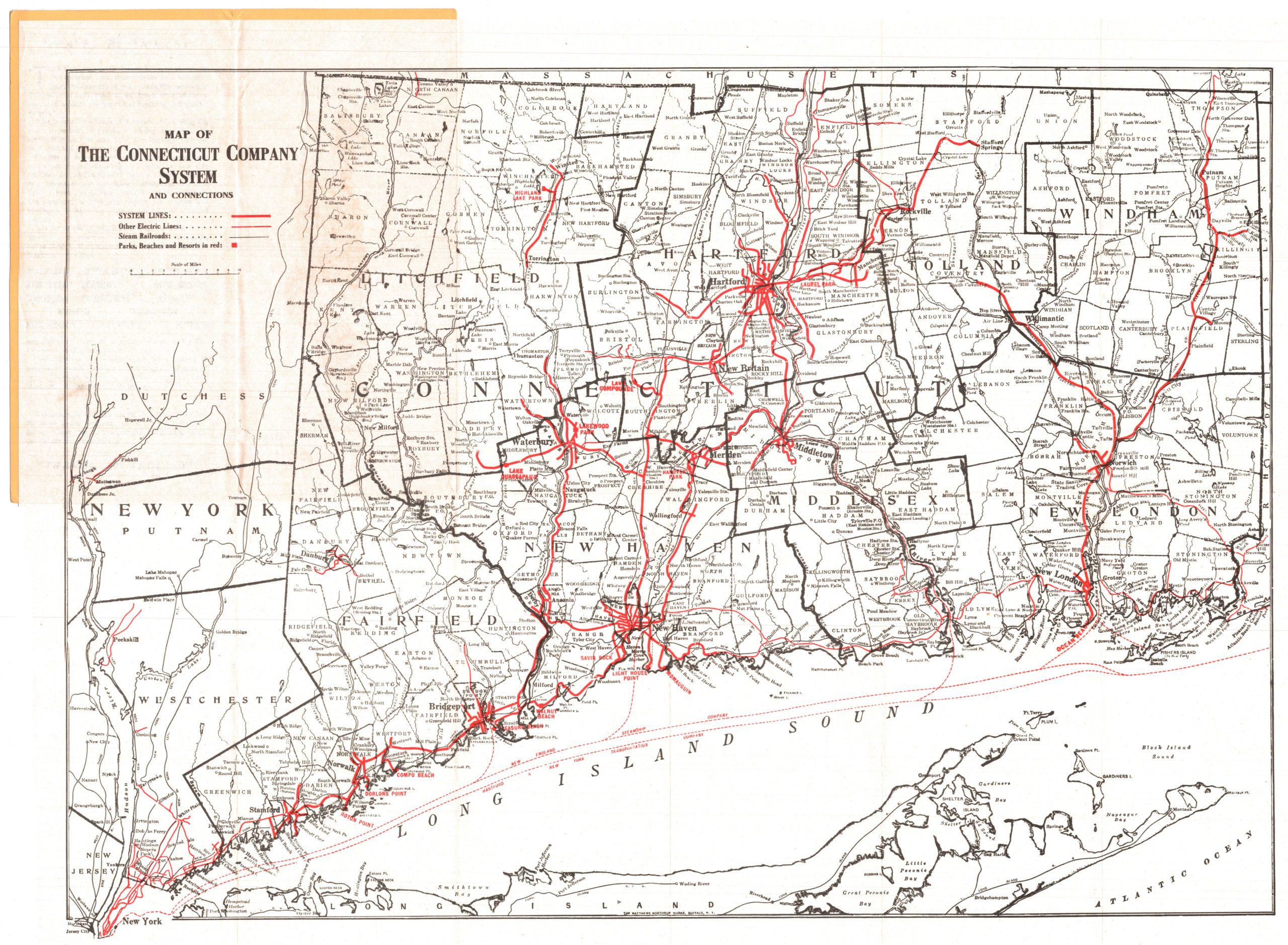
The Map of the Connecticut Company System and Connections. Traffic Department, New Haven, Connecticut, 1915-1929. Connecticut Museum of Culture and History.
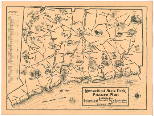
Connecticut State Park Picture Plan. Connecticut Forest and Park Association. 1929. Connecticut Museum of Culture and History.
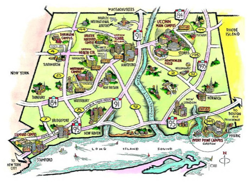
University of Connecticut (stylized road map), 2004. Archives & Special Collections at the Thomas J. Dodd Research Center, University of Connecticut Library, Map and Blueprint Collection.

Library of Congress Primary Source Analysis Tool Worksheet
ADDITIONAL RESOURCES
Places to GO
Connecticut Museum of Culture and History, Hartford
If you are already planning a field trip to a museum or other destination, try to acquire maps in advance (or print them from Google maps), so that your students can navigate on the way there or upon arrival.
Things To DO
Read a book for kids: Follow That Map!: A First Book of Mapping Skills by Scot Ritchie.
Read a book for teachers: Mapmaking with Children: Sense of Place Education for the Elementary Years by David Sobel.
Try one of the activities from We are Teachers: 20 Hands-On Ways For Kids to Learn Map Skills
Websites to VISIT
Map Skills for Elementary Students from National Geographic Society
National Geographic Resource Library Encyclopedic Entry: Map
Articles to READ
ConnecticutHistory.org:
- “Exploring Early Connecticut Mapmaking” by Kristen N. Keegan and William F. Keegan for Connecticut Explored
- “Putting History on the Map” by Nancy Finlay
- “From the State Historian: The Map That Wasn’t a Map” by Walter W. Woodward for Connecticut Explored
- “Why Was New Haven Divided into Nine Squares?” by Kim Sheridan